|
三個年代
縱谷斷層在1980年代就被認為是板塊縫合帶的重要活斷層,但是地表露頭卻不多,當時比較為人所知的,就是池上斷層在大坡村擋土牆的破裂,是安朔葉教授的博士班學生所發現的。1990年是個轉折點,安教授似乎對池上斷層開始產生了很大的興趣,開啓了一個二十年不間斷的研究。從大坡牆的地表斷層破裂為出發點,陸續在斷層南北延伸方向發現了數個地表破裂的露頭,包括大坡國小、南海天道圳溝、錦園溪圳溝、錦園村等等。事實上,安教授爾後每年都來到池上,進行斷層地表破裂露頭的觀察、量測及位移分析。這樣數年持續的堅持及努力,池上斷層快速潛移的特性被證實了;而且地表的露頭證據確實顯露無疑。池上斷層的科學意義在90年代後期開始聲名遠播,不僅台灣、甚且擴及全世界。 During the 1980s, the Longitudinal Valley Fault had been recognized as a major active fault of the plate suture; however, the surface fault trace was rarely seen and identified. At that time, the site of the Chihshang Fault was meant to be the rupture of the retaining wall of the Tapo village. It was first discovered by Professor Angelier's PhD students (Eric Barrier and Hao-Tsu Chu) in 1983. The turning point was the year 1990, when Professor Angelier began to take great interest in the Chihshang Fault as a research project, and since then it has lasted continuously for 20 years. Starting with the surface cracks of the retaining wall of the Topo Village, subsequent discoveries of several outcrops with surface ruptures were found extending southward to include: the Tapo Primary School, the Nanhaitientao Temple water channel, the Chingyuan water channel, the Chingyuan Village, etc. Since 1990, Professor Angelier has made it an annual ritual to return to Chihshang to proceed with surface rupture investigations, making measurements and fault displacement analysis. Several years of hard work finally resulted in the characterization of the rapid movement of the Chihshang Fault and its slip behaviors. In the late 90s, the scientific significance of the Chihshang Fault became well-known not only in Taiwan but also to the world. 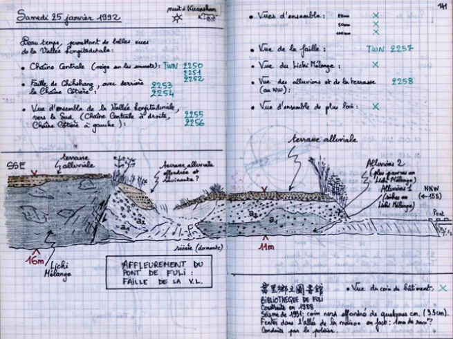
池上斷層露頭之一速寫,富里鱉溪南岸(1992)在台灣,能觀察到活斷層的地質露頭,其實是非常難得的;這主要是由於台灣地處潮濕的亞熱帶,地表岩石快速的侵蝕及沈積,加上茂密的植被,使得地質露頭的出露,尤其是年輕的活斷層,非常稀少。這個目前唯一僅被報導過的池上斷層地質露頭,位於富里鄉鱉溪南岸,然而在近幾年的河道築堤保護下,已經被雜草掩蓋較難見到。本圖在安教授1992年的描繪紀錄,更顯得珍貴。 Chihshang Fault outcrop, Fuli (1992)In Taiwan, the observable outcrops of active faults are limited as Taiwan is located in a humid and hot subtropical region, with rapid erosion, fast sedimentation, and heavy vegetation. Up to now, this is the only Chihshang active fault outcrop that has been reported. It is situated at the southern bank of the river Beichi, Fuli. In recent years, this outcrop was covered by vegetation and the retaining wall of the river. Professor Angelier drew this sketch in 1992 during early years of his long research in Chihshang. 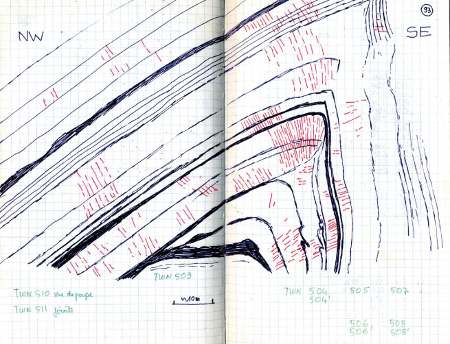
大坡牆斷層破裂特寫,池上(1990及1992)大坡牆的斷層破裂,1982年首先被安朔葉教授的博士生巴利葉與中央地質調查所朱傚祖先生發現並報導,但隨著1985年重建新牆,斷層破裂露頭也跟著消失。直到1990年,在安教授的野外調查中,發現新牆又在原址產生新的破裂,當下把它描繪下來(左圖),並紀錄了斷層破裂的位移量。之後的數年中,每年都回到牆前,描繪斷層破裂的發展近況。右圖為1992年的紀錄,不但斷層破裂更厲害了一些,而且位移量有持續增加的趨勢。事實上,1991年又發現了大坡溪溝渠及錦園溪溝渠兩個點,亦有類似的斷層破裂;1992年則發現南海天道溝渠的斷層破裂,也分別做了描繪及量測紀錄,並實施每年的重複觀測紀錄。 Fault Surface Rupture at Retaining Wall, Chihshang (1990, 1992)In 1982, surface ruptures on the Tapo road retaining wall were discovered and reported by Eric Barrier (Ph.D student of Professor Angelier) and Hao-tsu Chu of the Central Geological Survey. In 1985, the retaining wall was rebuilt so that evidence for the existence of the outcrop of the fault rupture has been eliminated. It was not until 1990, during a field survey, when Professor Angelier found that fault rupture had reoccurred at the same place as before. Then, he measured the displacement of the fault rupture and sketched it. Since then, in subsequent years, he has come back to take measurements once a year to understand the fault rupture propagation and one of the sketches in 1992 is given in the figure on the right. It shows that the fault rupture has not only been displaced more extensively than that in the previous year but also has been propagated continuously. In fact, all the findings of the fault ruptures of the retaining wall of both the Tapo River and the Chingyuan water tunnel in 1991, and the retaining wall of the Nanhaitientao Temple in 1992 has been recorded and since then repeated measurements have been made every year. 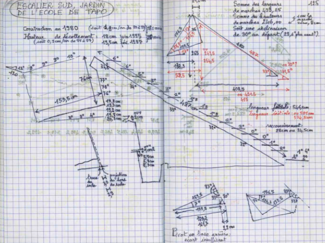
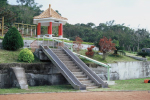
大坡國小滑梯傾斜分析,池上(1997)安朔葉教授似乎永遠有無窮的創意,他把這一點發揮在大坡國小的滑梯上。池上斷層除了在幾個點造成擋土牆、排水渠道及護岸等的斷層破裂外,在大坡國小則是讓滑梯傾斜(或"翹起來")。經過幾次的觀察,1995年,安教授開始把滑梯的結構及與地面和牆面的角度距離,做了一個很仔細的測量;而且也實施每年的重複測量,由此可以把滑梯的傾斜與斷層上盤的抬升量結合起來,估計斷層的位移及速率。爾後,「大坡國小的滑梯」逐漸變成了池上斷層的地標,國際上都享有很高的知名度。 Geometric analysis of tilted slider (1997)Professor Angelier seems to have endless innovations; he has skillfully applied them to the slider of the Tapo Primary School. Besides the fault ruptures that have occurred at the road retaining wall, the water channel, and the river retaining wall, the Chihshang fault has also "up-buckled" the slider of the Tapo Primary School. In 1995, Professor Angelier started to take detailed measurements repeatedly on the structure of the "up-buckle" slider every year. The displacement and the rate of fault movement could be estimated based on the geometry calculation. Since then, the "up-buckle" slider of the Tapo Primary School has gradually not only become the land mark of the Tapo Village but also well-known all over the world for witness of active faulting. 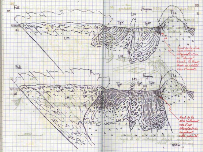
池上斷層地質剖面練習(1998)池上斷層是個板塊縫合帶邊界斷層,沿著池上斷層,屬於菲律賓海板塊的海岸山脈逆衝到第四紀沖積層的縱谷上。海岸山脈是個島弧系統,有火山岩基盤及弧前濁流岩等。在板塊碰撞作用中,海岸山脈內部受到相當的變形作用。這張跨越池上斷層的地質剖面示意圖,是安教授在富東公路經過地質調查後,所繪出富里到豐南的剖面,可以顯示他地質繪圖的功力,並帶有濃厚藝術家色彩。 Geological profiles across the Chihshang Fault (Essay) (1998)The Chihshang Fault is a major geological fault at plate suture, along which the Coastal Range of the Philippine Sea plate is thrust over the Quaternary alluvium deposits of the Longitudinal Valley. The Coastal Range belongs to the island arc system, which is composed of basal volcanic complex and forearc turbudite deposits. During plate collision, the internal part of the Coastal Range was subjected to certain deformation. Professor Angelier drew a structural profile across the Chihshang Fault, after finishing the geological survey along the Fu-Tung road. His geological sketch is seen here to be imbibed with artistic sense. 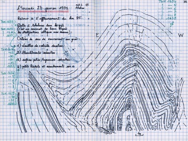
褶皺及斷層,阿里山塔塔加公路(1991繪)大自然的作用會讓岩石展現各種風情。彎曲褶皺的條紋,配上不同的顏色,總是讓人驚艷。安教授在地質調查的過程中,總喜歡將這些「漂亮的地質露頭」,用地質學家的筆觸描繪下來,加上一些觀察及地質背景的註記。 Fold and Fault, Alishan (1991)Natural processes usually could shape rocks with various expressions of folded curves and different colors. It will never stop to surprise people. In geological studies, Professor Angelier quite often would like to sketch such splendid geological outcrops with some geological observations and notes. |

